SAVOY EXPERIMENTAL WATERSHED
Projects
Scientific Rationale for Watershed Research“The goal of hydrologic science is to understand and predict the fluxes and storage of water over a range of space and time scales. Such understanding also is necessary to comprehend and predict fluxes and storage of sediments and solutes and to evaluate the suitability of the aquatic environment for living organisms. Experimentation is an essential part of science; in order to understand a phenomenon, it must be measured. Although many individual components of the hydrologic cycle (e.g., free-surface flow, porous media flow, evaporation, chemical transport) can be studies in the laboratory under carefully controlled conditions, the partitioning of rainfall into interception, infiltration, direct surface runoff, evaporation, and groundwater recharge, taking into account the natural temporal and spatial variability of rainfall and soil and vegetative characteristics, can be observed in a meaningful way only at the watershed scale.”
Committee on U.S. Geological Survey Water Resources Research, Water Science and Technology Board Commission on Geosciences, Environment, and Resources,National Academy of Sciences, 1997, p. 20.
The underlying theme of SEW research and projects is… “cooperating to establish and maintain a long-term research site for comprehensive, multidisciplinary research of animal waste impacts on surface and subsurface water quality.” Presented here is a brief overview of our hydrogeologic efforts to evaluate processes, controls, and hydrologic and nutrient-flux budgets quantitatively here at Savoy, so that we might share this understanding for the benefit of not only the researchers, but all who are in any way involved with animal production, water quality, and environmental issues. By carefully defining the boundaries of ground-water basins, knowing the exact land use that occurs in each of our basins, and monitoring the water quality that results in a field-scale, real-world setting, it is possible to test numerous hypothesis about animal production methods and resulting water quality. Not only can we propose new best-management practices, we can test, modify, and document much more rigorously in this controlled location than is possible in most other settings.
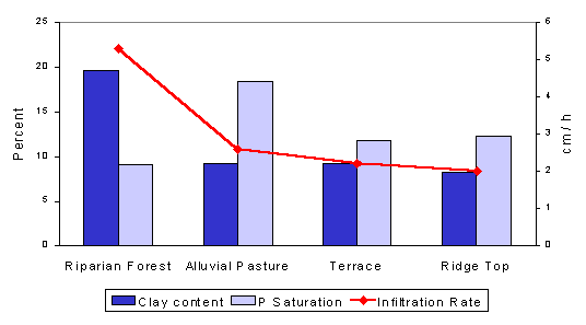
Variation in surface soil properties at different positions in the landscape
Samples taken from the riparian forest at the Basin 1 outlet on up to the top of the ridge showed significant changes in infiltration rates and clay content. These trends indicate that the riparian forest, with its higher infiltration rate and clay content, may be a sink for nutrients exported from Basin 1.
Poultry litter effects on runoff water quality
Sixteen pairs of 1x2 m runoff plots were established on Nixa and Clarksville soils at two locations. One plot of each pair received 4.5 Mg ha-1 poultry litter. A rainfall simulator was used to apply a 25-year storm one month after litter application. Runoff water was collected and analyzed for P and N parameters. Few statistically significant differences between litter-treated and control plots were found except for the forested site.


Water quality within and adjacent to Basin 1
Samples from the springs, deep and shallow wells, small seeps, Clear Creek, and the Illinois River have been analyzed for several water quality parameters. These data provide background information for assessing how basin water quality responds to future management changes and animal waste inputs. Data are interpreted as to whether the source is increasing or diluting the level of each parameter when compared to its concentration in the Illinois River.


Spatial variability of soil test phosphorus
In January of 1999, 66 soil cores were taken on a 30 x 30 m grid in a pasture paddock within Basin 1 called Cellar Ridge. These cores were analyzed to determine soil test phosphorus (STP) content using the Mehlich III method. In this 14.7 A paddock, STP ranged from 9.8 to 234 lbs/A with a mean value of 64 lbs/A. Most of the paddock had STP below the level recommended for optimal forage growth (100 lbs/A) reflecting the low level of fertilizer and/or animal waste inputs. Three areas of high STP were identified and one of these areas was associated with past animal waste applications.
Water quality modeling with AGNPS
Version 5.0 of the Agricultural Nonpoint Source Pollution (AGNPS) model is being used to predict nutrient (nitrogen and phosphorus) transport from Basin 1. Three runoff events have been simulated and the results compared to data collected at the runoff weir. Plans are to implement an updated annual version of AGNPS (AnnAGNPS) to improve nutrient transport simulations for Basin 1 including annual loads.